What is the Catalan Atlas?
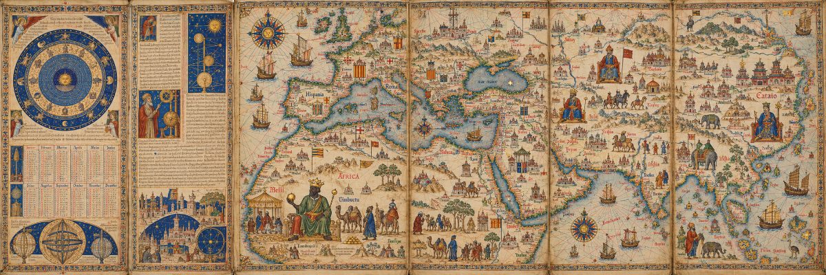
The Catalan Atlas is a medieval world map produced around 1375, widely considered the most important map of the Middle Ages, and the reason it matters to this conversation is that it carries one of the most striking images of the Mali Empire ever made: a portrait of Mansa Musa, ninth mansa of Mali, seated on a throne, holding a ball of gold, drawn by a Jewish cartographer on an island off Spain.

Answer from Mary's digital twin. Checkmark turns Green once she confirms it.
 spio.com
What it is
The Catalan Atlas is a medieval world map, or mappa mundi, probably created in the late 1370s or early 1380s, often conventionally dated 1375, and has been described as "the zenith of medieval map-work." It was prepared in Palma de Mallorca by Abraham Cresques and his son Jafuda Cresques. Abraham was a Jewish cartographer working within the Majorcan cartographic school, the leading center of map-making in the medieval Mediterranean world. Given as a gift to the French king, it has long been kept in Paris, now held at the National Library of France.
The atlas originally consisted of six sheets of parchment. The first sheets deal with cosmography, astronomy and astrology, and practical advice for sailors is also provided. The Catalan Atlas is a world map built up around a portolan chart, combining the nautical chart's coastal detail with the medieval tradition of illustrated world maps, representing a transitionary step toward the world maps developed later during the Renaissance.
A portolan chart, to explain the term, was a navigational tool sailors actually used at sea. It showed coastlines in precise detail and used lines called rhumblines to plot compass bearings. What makes the Catalan Atlas extraordinary is that it combines that working sailor's tool with a mappa mundi, the grand illustrated picture of the whole known world, from West Africa to the Pacific coast of East Asia.
Mansa Musa and the gold
This is where it connects directly to our conversation. The Catalan Atlas has received increased attention in recent years for its powerful depiction of Mansa Musa of Mali, crowned and enthroned, gazing at a golden ball held in his fingertips. Enthroned with a golden crown, scepter, and orb, he is described in the accompanying text as "the richest and the noblest sovereign of all this region because of the abundance of gold that comes out of the land."
The caption in the atlas reads:
"This black Lord is called Musse Melly and is the sovereign of the land of the black people of Gineva. This king is the richest and noblest of all these lands due to the abundance of gold that is extracted from his lands."
The atlas is richly illustrated with figures depicting the famous monarchs of the world, their kingdoms, and their enemies at war. The written sections identify well-known cities, biblical places, exotic animals, and coveted commodities such as gold from Africa, pearls from the Persian Gulf, and spices from Asia.
Why it matters for this thread
This map was drawn roughly 50 years after Mansa Musa's famous hajj to Mecca, and his wealth was still so legendary it had worked its way into European consciousness all the way to a cartographer's workshop on a Mediterranean island. The 1375 Catalan Atlas also portrayed a "city of Melly" in West Africa. The Mali Empire was not some vague rumor to 14th-century Europeans: it was on the map, its king was named and illustrated, and the gold was the point.
The atlas also sits at the intersection of several threads we have been following. It was made by Jewish scholars working in the Crown of Aragon, drawing on Arab geographic sources and traders' accounts, including the kind of trans-Saharan trade networks that carried Islam into Mali alongside the gold routes. The world these maps described was already deeply connected, and the people at the center of it were African.
Follow-ups
Did Geneva stem from Gineva? The Catalan Atlas refers to "Musse Melly, senyor dels negres de Gineva."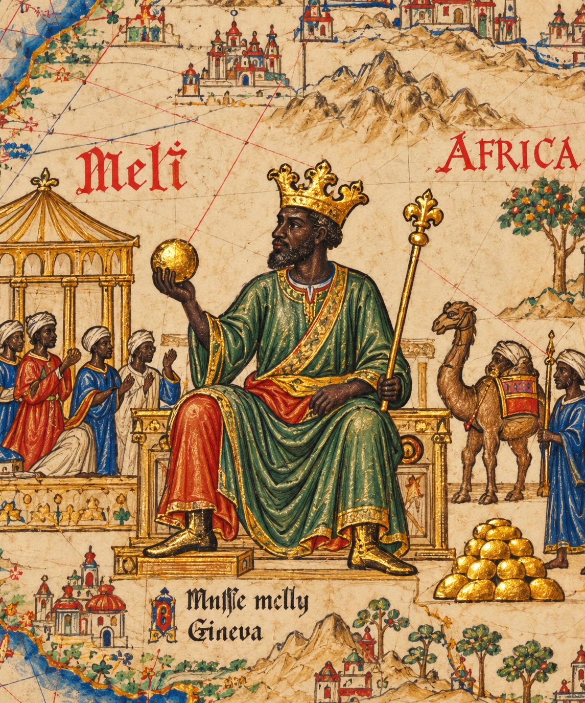 The two words share an ancient root but point to completely different places: "Gineva" in the Catalan Atlas is not the Swiss city of Geneva but a medieval Catalan rendering of Guinea, the West African region that Mansa Musa ruled, while the Swiss city Geneva traces its name to the Celtic-Latin "Genava," meaning estuary
 or bend in a river, making the resemblance a phonetic coincidence from two separate etymological lines.
spio.comWhat the Atlas actually says
The Catalan Atlas, the medieval world map produced around 1375 by Abraham Cresques on the island of Majorca, carries two inscriptions about Mansa Musa, ninth mansa of the Mali Empire. One reads: "Through here pass the merchants who travel to the land of the negroes of Guinea," referring to the Valley of the Draa. The other reads: "aquest senyor negre es appellat musse melly, senyor dels negres de Gineva," translated as "This black gentleman is called Mansa Musa and is the ruler of the negroes of Guinea. This king is the richest and noblest gentleman in all the region on account of the abundance of gold that is obtained from his land."
So "Gineva" in the Atlas is simply the 14th-century Catalan spelling of Guinea, the broad West African region that Musa commanded. The Cresques Project, which catalogues the Atlas's original legends, translates "Gineva" in one inscription as Ghana and in another as Guinea. Modern editors use both words interchangeably for the same territory because in medieval European cartography the distinction between the Ghana Empire and the broader region called Guinea was blurred, and Catalan scribes were writing the sounds they heard from Arab and North African traders, not from any standardized geography.
Where "Geneva" actually comes from
It was mentioned in Latin texts by Julius Caesar with the spelling Genava, probably from a Celtic toponym genawa from the stem genu, meaning "bend" or "knee," in the sense of a bending river or estuary. From Latin Genava, the meaning was likely either "estuary" or "bend," in either case a reference to the city's physical situation where the Rhône exits Lake Geneva. The city in origin shares its name, genawa meaning "estuary," with the Italian port city of Genoa, known in Italian as Genova.
So the chain for Geneva is: Celtic genawa → Latin Genava → Old French Genève → English Geneva. The chain for Gineva is entirely different: it is Catalan ears transcribing an Arabic or Berber name for a West African land, most likely connected to the great trading city of Djenné on the upper Niger River. Leo Africanus, writing in 1526, argued that the word "Guinea" itself derives from Djenné, which he referred to as Gheneo, Genni and Ghinea.
When Each Name First Appears
- 58 BCE, Julius Caesar, Roman general and statesman: in Commentarii de Bello Gallico (The Gallic War), Book 1, Chapters 6 and 7, Caesar describes a town called Genava by the Rhône River. He names it the farthest town of the Allobroges, nearest the territory of the Helvetii, and describes ordering its bridge destroyed. This is the earliest widely cited written record of Geneva. The events took place in 58 BCE, and Caesar wrote his account later, during his campaigns in Gaul.
- 1375 CE, Abraham Cresques, Jewish cartographer of Majorca: more than 1,400 years after Caesar's account, the Catalan Atlas names Mansa Musa as "Musse Melly," ruler of the Black people of Gineva.
Caesar wrote:
“The furthest town of the Allobroges, and the nearest to the territories of the Helvetii, is Geneva. From this town a bridge extends to the Helvetii.”
Source: Perseus Digital Library, The Gallic War, Book 1, Chapter 6
Why the sounds converge
This is the same pattern at the heart of this whole conversation. A hard "G," a front vowel and a nasal consonant produce a cluster of sounds that appears independently across unrelated language families: Celtic, Catalan, Mandé, Arabic. When medieval European cartographers heard West African place names through Arabic intermediaries, they wrote them in the Catalan spelling conventions they already knew, which happened to produce a word that looks exactly like their own name for a Swiss city. The overlap is phonetic, not historical.
The deeper point is one I keep returning to: medieval Europeans knew far more about the wealth and geography of West Africa than the standard telling admits. Abraham Cresques drew the richest man on earth sitting on his throne in the middle of his map, named his territory, described his gold, and marked the trade routes merchants used to reach him. That knowledge came through Arab scholars, North African traders, and the Majorcan Jewish community's remarkable network of contacts. "Gineva" is a phonetic artifact of that network, not a borrowing from Switzerland.
Why do cultures around the world show black gods? From Krishna to Buddha and Hắc Hổ. Where did this tradition start?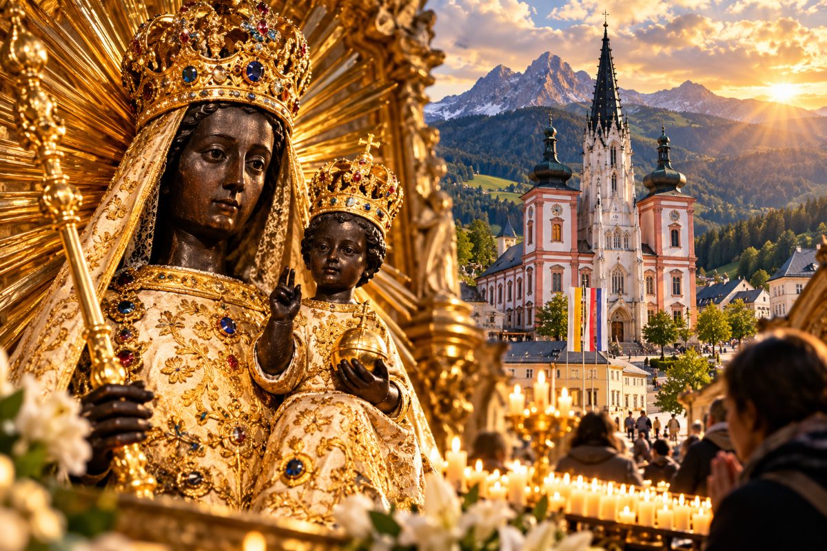 The pattern of dark or black divinity runs across nearly every ancient civilization on earth, from Egypt's Osiris and India's Krishna to Vietnam's Hắc Hổ, and the most honest answer to where it started is: Africa, because that is where human beings themselves started, and the first people who conceived of gods conceive
d them in their own image.
spio.comThis conversation has been following the thread of Africa's influence across world civilization, from Mansa Musa and the Mali Empire to Maat and the Catalan Atlas. This question may be the deepest one in the thread.
The name itself carries the answer
The name "Krishna" originates from the Sanskrit word kṛṣṇa, which means "black", "dark" or "dark blue." That is not a secondary detail buried in a footnote. It is the first word of the god's name. In accordance with the meaning of the name, Krishna murtis are often depicted with black or blue skin. The question then is: why did the dominant culture of ancient India preserve a black god as its central deity? If Vedic Hinduism was brought by light-skinned Aryans who had come to dominate India, why did they choose so many dark-skinned gods as their principal deities? Two of the most popular deities of Hinduism, Ram and Krishna, both incarnations of Vishnu, are described as dark-skinned. The answer scholars offer is that the dark-skinned deities came to Hinduism from the indigenous people of India, as the two groups assimilated and intermixed their deities.
And it goes deeper. The goddess Kali, the dark-skinned deity of Hinduism, is venerated among the Shakta traditionists and widely venerated across all of India. Darkness, in the oldest Indian religious imagination, was not evil. It was power.
Hắc Hổ, Vietnam's Black Tiger of the North
Hắc Hổ literally means Black Tiger in Vietnamese. It is not a demon or a villain. In Vietnamese folk belief linked to the Mother Goddess worship, the Hắc Hổ, the Black Tiger Goddess, governs the north. In Vietnamese folk paintings, the "Five Tigers" are depicted in five colors symbolizing the five directions: the Yellow Tiger guards the center, the Black Tiger guards the North and the water element, the White Tiger guards the West, the Red Tiger guards the South, and the Green Tiger guards the East. So the Black Tiger is not marginal. It holds a cardinal direction and a primary element. The tiger gradually became a guardian deity in Vietnamese folk beliefs, and its transformation reflects centuries of interaction between indigenous traditions and Taoism.
The Buddha
The earliest depictions of the Buddha in the most ancient temples of Asia show him differently from the Chinese, Japanese and Korean images most people recognize today. It is only centuries later, when Buddhism was introduced outside of India, that the Buddha took on Chinese, Japanese, Korean and other Asian features. The first and original Buddha was a dark-skinned man. The hair is the detail historians keep returning to: the tight curls, rendered in peppercorn style or cornrows in early sculpture, point back toward a specific physical type that carries its own geographic story.
The Black Buddha and Sambo
Some believe Sambo was once a name tied to the Black Buddha. In Japanese, sambō means the Three Jewels of Buddhism: the Buddha, his teachings and the community that keeps them.
It's interesting that when people hear Sambo today, they think of a Black caricature, not a Black Buddha. It shows you the level of erasure, and how these sacred images have been replaced with a caricature.
The caricature spread with The Story of Little Black Sambo, published in 1899 by Helen Bannerman, about a boy in southern India.
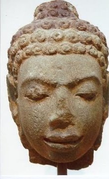 A Black Buddha: stone head with tight curls
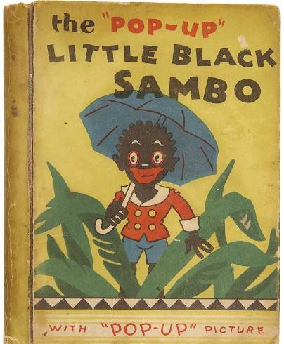 The caricature: Little Black Sambo
Egypt's Osiris and the title "Lord of the Perfect Black"
Back in this conversation's home territory: Osiris, the greatest of the Egyptian gods, was sun-rayed and Black with woolly hair. His chief title means "Lord of the Perfect Black." Osiris was not incidentally depicted this way. The blackness was the point: it signified fertility, the rich dark soil of the Nile flood, the underworld from which life regenerates, and divinity itself. This is continuous with everything this thread has covered about Maat: the oldest formal architecture of cosmic order, justice and divine judgment comes from the same civilization.
Why the pattern is global
The simplest explanation is also the one that fits the evidence. Every human being on earth descends from ancestors in Africa. The people who first developed religion, who first gave form to the idea of a creator, a judge, a protector, were African people, and they made those figures in their own image. As those populations migrated across Asia, the Middle East and the Americas over tens of thousands of years, they carried their cosmologies with them. Later arrivals did what every conquering or assimilating culture does: they absorbed the gods of the people already there, renamed them, recolored them in some places, and kept them in others. Many of the world's first deities and divinities, both male and female, were originally depicted as Black.
The whitening came later, and it was rarely complete. An unnaturally blue Krishna was preferred over a naturally dark Krishna, because the color could be shifted without erasing the god entirely. The name, the myth, the power: those survived. They survive in the very word Krishna. They survive in Hắc Hổ guarding the northern direction. They survive in every Black Madonna found across Catholic Europe and Latin America, seated at the center of a tradition that needed her too much to replace her.
The thread that runs from Maat's feather to the Catalan Atlas portrait of Mansa Musa runs through here too. Civilization did not begin in Europe and spread outward. It moved the other direction first, and the gods went with it.
Black Gods and Sacred Figures Around the World
From Krishna in India to the Black Buddha traditions of Asia, and on to Africa, Europe and the Americas, Black and dark-skinned divine figures appear in religious traditions across the world. They are in Hinduism, Buddhism, African traditional religions, Christianity and indigenous spiritual systems.
1. India: Hindu Gods and Goddesses
India has some of the clearest and oldest traditions of dark-skinned divinity.
| Divine figure | Tradition | Significance |
|---|---|---|
| Krishna | Hinduism | His name is commonly interpreted as "dark" or "black." He is depicted as dark-skinned or blue-black |
| Kali | Hinduism | Powerful goddess frequently represented with black or deep-blue skin |
| Shiva | Hinduism | Appears in different colors and forms, including dark manifestations |
| Vishnu | Hinduism | Often represented with dark-blue skin |
| Rama | Hinduism | Traditionally described as dark-complexioned and often depicted blue |
| Draupadi Amman | Tamil Hindu traditions | A deified heroine sometimes represented with dark skin |
| Karuppasamy | Tamil folk Hinduism | A protective deity whose name and images emphasize blackness |
| Mariamman | South Indian Hinduism | Goddess of rain, protection and healing; some regional images show her with dark skin |
| Mahakala | Hindu and Buddhist traditions | A dark or black protector whose name means "Great Black One" or "Great Time" |
 VishnuVishnu on Garuda, Metropolitan Museum of ArtSource: Wikimedia Commons
 RamaSouth India, about 1820, British MuseumSource: Wikimedia Commons
Krishna stands out: dark coloring is central to his name and identity, not just an artistic choice.
2. Vietnam: Black Guardian Deities and Buddhist Figures
Vietnam has traditions of black divine protectors.
| Figure | Tradition | Significance |
|---|---|---|
| Hắc Hổ (Black Tiger) | Vietnamese Mother Goddess worship | Sacred black tiger guarding the north |
| Đại Hắc Thiên (Mahakala) | Vietnamese Buddhism | A dark protector inherited from Indian Buddhist traditions |
| Dark guardian figures | Vietnamese Buddhist and folk temples | Some guardians have black or dark faces symbolizing protective power |
The Five Tigers tradition is well documented: yellow, green, white, red and black tigers stand for different directions and cosmic forces.
3. China, Tibet, Nepal and Japan
| Culture | Figure | Description |
|---|---|---|
| Tibet | Mahakala | Black or dark-blue protector of the Buddhist teachings |
| Tibet | Palden Lhamo | Fierce protective goddess often depicted dark blue |
| Tibet and Nepal | Black Tara | Dark form of Tara in some tantric traditions |
| Nepal | Bhairava | Fierce form of Shiva, sometimes represented in black |
| China | Heitian / Daheitian | Chinese forms of Mahakala, the Great Black Deity |
| China | Xuanwu | Deity of the north, associated with black and water |
| Japan | Daikokuten | Deity derived from Mahakala, later associated with prosperity |
| Japan | Fudō Myōō | Buddhist protector sometimes depicted with dark-blue or black skin |
 Mahakala (Tibet)Thangka, Central Tibet, 1400sSource: Wikimedia Commons
 Black TaraHimalayan Buddhist imageSource: Wikimedia Commons
Mahakala traveled from India into Chinese, Tibetan and Japanese traditions, a documented example of a dark deity crossing cultures.
4. Africa: Egypt, Nubia and West Africa
| Culture | Figure | Description |
|---|---|---|
| Ancient Egypt | Osiris | Sometimes depicted with black skin; fertility, regeneration and the afterlife |
| Ancient Egypt | Anubis | Black jackal-headed god of embalming and the dead |
| Ancient Egypt | Isis (Auset) | Major goddess depicted in different skin tones, some of them dark |
| Ancient Egypt | Min | Fertility god frequently depicted with black skin |
| Ancient Egypt | Amun | Major god of Egypt and Nubia, sometimes represented with dark-blue skin |
| Yoruba | Eshu | Orisha of crossroads, communication and transformation |
| Yoruba | Ogun | Orisha of iron, technology, warfare and craftsmanship |
| Yoruba | Shango | Orisha of thunder, lightning and royal authority |
| Yoruba | Yemoja | Divine mother of the waters and motherhood |
| Akan | Asase Yaa | Earth goddess of fertility and the land |
| Fon and Ewe | Mawu-Lisa | Divine creative principle with feminine and masculine sides |
 OsirisCopy of a tomb painting, Thebes, about 1386–1330 BCE, MetSource: Wikimedia Commons
 Isis (Auset)Isis leading Queen Nefertari, copy of her tomb painting, MetSource: Wikimedia Commons
Ogun, Shango and the other orishas are shown in human forms that look like the communities who honor them. Their identity is not defined by black skin the way Kali's or Mahakala's is.
5. Europe: Black Madonnas and Sacred Images
Europe has a long tradition of honoring dark-skinned images of Mary and Jesus, some dating to the medieval period.
| Country | Sacred figure | Location |
|---|---|---|
| Poland | Black Madonna of Częstochowa | Jasna Góra Monastery |
| Spain | Our Lady of Montserrat | Catalonia |
| France | Black Madonna of Le Puy | Le Puy-en-Velay |
| France | Black Madonna of Rocamadour | Rocamadour |
| France | Notre-Dame de la Daurade | Toulouse |
| Italy | Madonna of Loreto | Loreto |
| Italy | Madonna of Tindari | Sicily |
| Italy | Madonna of Oropa | Piedmont |
| Switzerland | Black Madonna of Einsiedeln | Einsiedeln Abbey |
| Germany | Black Madonna of Altötting | Bavaria |
| Czech Republic | Black Madonna of Brno | Brno |
| Austria | Black Madonna of Loretto | Basilica Maria Loretto, Burgenland |
 CzęstochowaJasna Góra Monastery, PolandSource: Wikimedia Commons
 Montserrat (La Moreneta)Basilica of Montserrat, CataloniaSource: Wikimedia Commons
 Le PuyLe Puy-en-Velay Cathedral, FranceSource: Wikimedia Commons
 RocamadourChapelle Notre-Dame, Rocamadour, FranceSource: Wikimedia Commons
 La DauradeBasilica of La Daurade, ToulouseSource: Wikimedia Commons
 TindariTindari sanctuary, SicilySource: Wikimedia Commons
 OropaOropa sanctuary, PiedmontSource: Wikimedia Commons
 AltöttingChapel of Grace, Altötting, BavariaSource: Wikimedia Commons
 BrnoChurch of St. Thomas, BrnoSource: Wikimedia Commons
These are Christian sacred figures, not separate goddesses.
6. The Americas: Black Sacred Figures
| Country | Figure | Tradition |
|---|---|---|
| Guatemala | Black Christ of Esquipulas | Catholic devotion, honored across Central America and Mexico |
| Brazil | Nossa Senhora Aparecida | Black Madonna; patroness of Brazil |
| Brazil | Iemanjá | Afro-Brazilian orisha |
| Brazil | Oxum | Afro-Brazilian orisha |
| Cuba | Changó | Afro-Cuban Santería |
| Cuba | Yemayá | Afro-Cuban Santería |
| Haiti | Ezili Dantò | Haitian Vodou lwa, often depicted as a dark-skinned mother |
| Haiti | Ogou | Haitian Vodou lwa of iron, power and warfare |
 Black Christ of EsquipulasBasilica of Esquipulas, GuatemalaSource: Wikimedia Commons
 IemanjáStatue in Vitória, BrazilSource: Wikimedia Commons
 ChangóYoruba figure of Shango on horseback, Brooklyn MuseumSource: Wikimedia Commons
 Ezili DantòHer vevé, the sacred symbol drawn for her in Haitian VodouSource: Wikimedia Commons
 OgouHis vevé, the sacred symbol drawn for him in Haitian VodouSource: Wikimedia Commons
Some are African divinities carried across the Atlantic by enslaved Africans. Others are Christian images that grew within local traditions.
7. The Philippines, India and Sri Lanka
| Country | Sacred figure | Significance |
|---|---|---|
| Philippines | Black Nazarene | Dark-skinned image of Jesus carrying the cross, honored in Manila |
| India | Dhori Mata | Black Madonna honored at Bokaro, Jharkhand |
| Sri Lanka | Kataragama Deviyo | Regional deity sometimes shown with dark skin; linked to Skanda/Murugan |
 Black NazareneQuiapo Church, ManilaSource: Wikimedia Commons
Dhori Mata is a black wooden statue of Mary and child found in a coal mine in 1956. The miners first thought it was the Black Goddess Kali.
What stands out across these cultures?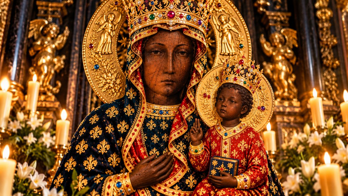 At least 4 patterns stand out: darkness as a divine attribute, darkness as sacred symbolism, African religious continuity and dark-skinned Christian images.
spio.comThere are at least 4 distinct patterns:
- Darkness as a divine attribute. Figures such as Krishna, Kali and Mahakala are tied to blackness or darkness in their names, descriptions or images.
- Darkness as sacred symbolism. In some Egyptian and Asian traditions, black stands for fertility, regeneration, cosmic forces, protection or a direction.
- African religious continuity. Yoruba and other African divine traditions survived and grew in Brazil, Cuba, Haiti and beyond.
- Dark-skinned Christian images. The Black Madonnas and Black Christ images have been honored across Europe, Asia and the Americas for centuries.

The ancient Greeks were voracious borrowers. Their debt to Africa was enormous and openly acknowledged by the Greeks themselves. Thales of Miletus, credited as the first Greek philosopher, studied geometry in Egypt. Pythagoras spent years there. Plato visited.
Read that one firstThe story of Mali is exactly the kind of history CEEK was built for.
Join a community posting daily on the empires, languages and discoveries that the standard curriculum left out.
Join me on CEEK
Comments
Comments are public. Links are removed.